
USGS Streamflow Data Feature
A new feature has been added to Fish Swami to help make entering in fishing logs even easier. With the help of USGS streamflow data, Fish Swami can auto-populate the water level and water temperature fields when you add a new fishing log entry.
Link Your Fishing Spot to a USGS Site
In order for Fish Swami to look up streamflow data to your fishing log, you must first link a USGS site to your fishing spot. You can link the USGS site either when you create your fishing spot, or when you edit an existing fishing spot. I’ll walk through linking a USGS site to a new fishing spot, but the editing process is very similar.
Adding a New Fishing Spot
Once you’ve logged in to Fish Swami, click on the My Fishing Spots link on your home page. You’ll be taken to a directory of all of your saved fishing spots. From this page, click the Add a new fishing spot button to add a new fishing spot. As an example, let’s add the upper Snake River in Idaho as our fishing spot, like:
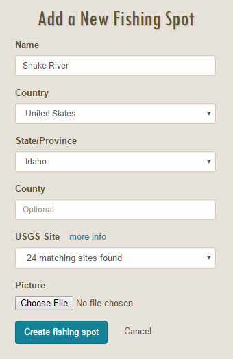
After entering in “Snake River” for the name and selecting “Idaho” for the state, the USGS Site dropdown will automatically fill in with matching sites queried from the USGS service. In this case, there were 24 matching sites found. After looking through the list, we decide that the Snake River near Irwin ID site is the nearest site to where we usually fish on the Snake River. Finally, click the Create fishing spot button to save the fishing spot information.
Adding a New Fishing Log Entry
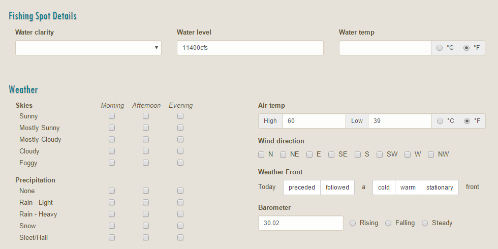
To add a new fishing log, navigate back to your home page by clicking the MY HOME menu item. From the home page, click the Add a new fishing log button. On the log entry page, select Snake River as the Water, and select May 28th, 2016 as the date. After selecting both the water and the date, Fish Swami will query the USGS services again to find streamflow information for May 28th, and enter in the data automatically in the Water level field. Additionally, the USGS linkage provides Fish Swami with GPS coordinates of the USGS site, so Fish Swami is also able to look up air temperature highs and lows for that location, as well as the barometer value. Here are the auto-populated fields:
Choosing a Different Date
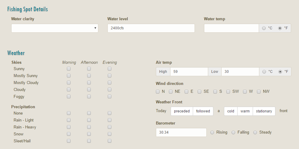
Perhaps you’ve been busy and haven’t had a chance to enter in a fishing log from a couple weeks ago. Fish Swami is able to pull historical streamflow and weather data for your fishing spots as well. To illustrate this, we can change the fishing log date from May 28th to October 21st, 2015 (maybe you’ve been really busy :). Fish Swami will update the Water level, Air temp, and Barometer fields:
Hopefully you find this feature useful!
Comments
Gary Franklin Krohn
A great fishing site