
Hydrographs for Steelhead
Go With the Flow
My alarm blared at 3AM and I rolled out of bed, stumbled into the kitchen and made some coffee, filled the thermos and jumped in the truck. A quick stop at a fishing buddy’s house and we were off to fish the Grande Ronde river.
As we drove through the darkness we chatted about where we caught steelhead last weekend, what runs we were going to fish and what flies we were going to use. Our excitement grew as we got closer to the river in anticipation of a good day of fishing. It was still dark as we wound our way down Rattlesnake Grade towards Boggans Oasis. We got to the river at first light and jumped out to check conditions and were horrified to find that the river was completely blown out! Our hearts sank and we knew it was not going to be a good day. We stayed and fished, but with no luck. The water was just too high and chocolate brown.
That was the day when I decided I needed to learn more about water gauges and hydrographs. Over the last 14 years I have learned how to identify some important river conditions using hydrographs that have increased my success as a steelhead fisherman. Here are some conditions every steelheader should know and what their corresponding hydrographs look like.
Hydrographs
A hydrograph is a graph showing the discharge (cfs), stage (depth), or other property of water with respect to time for a given location on a stream. The US Geological Survey has many gauges located on rivers that you can use to determine the condition of your favorite steelhead river. The gauges collect river flow, height, and sometimes temperature every hour and then transmit it back to the USGS where it is available on the USGS web site.
The USGS streamflow web sites are very easy to use and create nice graphs of the river flow over the last week to month. You can select different parameters for the gauge you are looking at to create a hydrograph. Typically the default is flow and stage over the last 7 days. I like to select flow and temperature (if it is available) over the last 14 or 21 days so I can see if there have been any water events, such as a recent freshette. You can even go back and gather historical river flow data from previous years.
The USGS web sites organize rivers by state and river drainage. Many rivers have multiple gauges and it is important to pick a gauge that is nearest where you want to fish. For example, if you are going to be fishing the Salmon River around Riggins you want to choose the White Bird gauge, not the Yankee Fork gauge. Looking at multiple gauges along the same river can be helpful in determining the whole river condition. For example, the gauge on the South Fork of the Clearwater at Stites (near the mouth) may show a dramatic rise in the river but the gauge at Elk River is holding steady. This may be OK if you plan to fish further upstream.
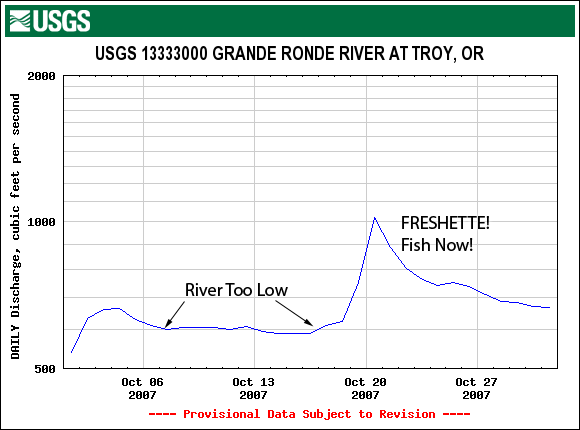
Figure 1
Figure 1 is a typical hydrograph for the Grande Ronde River at Troy, Oregon from October of 2007. It shows the river flow (in cfs) over the month compared to the historical average (the triangle data points). You can see that at the beginning of the month the river was flowing well below the historical average and then it jumped up from a rain storm on October 20th.
Fishy Freshettes
A freshette is a rise in the river level that improves migration conditions by increasing water flows and/or cooling the river. Freshettes are a magical condition that draw steelhead upstream toward their home rivers because the increased flows from tributaries increases the scent from that watershed into the main-stem river. Fish from that watershed are attracted to the smell and start moving upriver and into tributaries.
Rivers are often too low for fish to migrate in the Fall before the first freshette. For example, Figure 1 shows a hydrograph of the Grande Ronde from October of 2007. The first few weeks the water was running around 600cfs—too low for steelhead to want to move into the river. Then a rain event happened and the river shot up to 1,000cfs, which drew a bunch of fish into the river.
If you can, time your fishing trips to be right after a freshette when the river starts to fall and you will have good fishing conditions. Freshettes get fish moving—and moving fish are more likely to hit your fly!
Bad News Blowouts
A blowout is a period of significantly increased river flows after a heavy precipitation or snow melt event. The rapidly increased flows discolor the river, throw off steelhead and make it difficult to fish. Blown out rivers rise quickly and take days to recover. Recovery time depends on the size of the event and the drainage. Some rivers recover quickly and others can be out for a week. Spring blow-outs from snow melt are the worst, but Fall rains after a large forest fire, such as the one on the Main Salmon last year, can also significantly discolor a river and mess up your fishing.
Some drainages are more prone to blow-outs. The Ronde seems to be more volatile in the Spring. The upper Salmon River around Stanley recovers quickly but the lower Salmon takes longer because of the increased size of drainage. The Snake below Hells Canyon is immune to blow-outs because it is a tail-water.
Steelhead fishing is generally poor on rising rivers and worse in blowout conditions because of the lack of visibility. Blowouts from snow melt in the Spring are particularly bad because the melting snow lowers the river temperature to near freezing which makes fish sluggish. It is a little counter intuitive, but on a Spring blow-out you want a hard freeze to stop the snow-melt. Once the river starts to drop the sun will be able to warm the river better.
The main difference between a Freshette and a Blow-out is that a freshette improves the migration conditions and generally recovers quickly. A blow-out degrades the migration conditions and can be slow to recover. Blow-outs early in the Spring are not all bad as they draw fish upriver and into tributaries and burn off snow at lower elevations which will keep warmer days later in the season from blowing out the river.
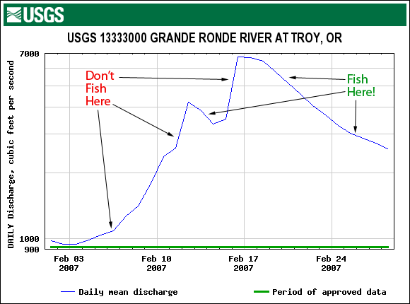
Figure 2
Figure 2 shows a blow-out on the Grande Ronde River in February of 2007. The river quickly rises from under 1,000 cfs to 4,000 cfs and then to 7,000 cfs before it starts to drop. You don’t want to fish as the river is rising. Instead look for the river to start to fall, and then go fishing. Blown-out rivers tend to be difficult to wade and fish because the river has risen into the brush and trees along the edge. If you do end up at a blown-out river look for side channels where the flow is reduced and fish very close to the bank.
Showing out at a blown-out river is avoidable. Simply check the river hydrograph before your trip. If you find that the river you plan to fish is blown-out, check the hydrograph on other rivers. Often if one river blows out others will still be fishable. The Clearwater may be blow out, but the Salmon or Ronde may be fine because they have significantly different drainages. And if everything is out of shape, don’t forget about the Snake River. The Snake River below Hells Canyon is essentially a tail-water fishery and so it doesn’t blow out. So if the Salmon at Riggins isn’t fishable, consider jumping over to the Snake at Pittsburg Landing. If the Main Clearwater is out of shape try fishing the NF of the Clearwater below Dworshak.
Checking the weather forecast is also helpful to see if a big storm is coming or if a Spring thaw is expected. A good rule of thumb I learned from John Hull (who used to run the Idaho Angler) is that if Stanley is getting below freezing at night the upper Salmon River will stay in fishable shape.
Different Level, Different River
Every year flows are different on the river, depending on the previous year’s snow pack, temperatures, fall rains, and in some cases dam outflow releases. The same river fishes different at different levels. One of my favorite holes on the Clearwater fishes best around 5,000 cfs. It isn’t there below 3,000 cfs and it is too fast over 7,000 cfs.
Keeping track of where you caught fish, what time of year, and at what flow will help you repeat the success the next time you’re at the river. A fishing log is a great way to do this, but you can also use historical hydrographs to look back at what the flows were last year when you caught fish. To get a hydrograph from a previous year, go to the river hydrograph site and change the “Time Series” parameter from “Real Time Data” to “Daily Data” and then set the date range.
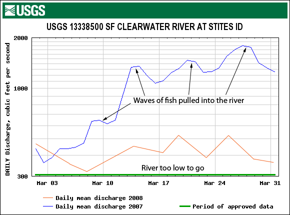
Figure 3
Figure 3 shows dramatically different river conditions on the SF Clearwater in March of 2007 vs. 2008. Last Spring the SF Clearwater was unusually low and there weren’t the normal freshettes to pull fish into the river. The river stayed low and very few fish moved into the river and fishing was poor. In March 2007 the river came up and fish moved into the SF Clearwater and then continued moving upstream. Fishing was great!
In low water conditions steelhead hold in deeper holes and don’t like to move. And the fish that do move are very spooky. In higher water steelhead will migrate upriver and typically hold closer to the edge of the river.
Too Low To Go
Some times rivers are so low that I consider them “too low to go” fishing. Hydrographs can help you determine when rivers are very low. Steelhead won’t move into low tributaries very well, and the fish that are there will be spooky. If the river flow is significantly below the historical average for the river, then it may be too low to fish well. There is no substitute for knowing a river and what levels it fishes well. Personally I’ve had better luck on the Ronde when flows jump up over 1,000cfs and when flows are above 4,000cfs on the main Clearwater.
Thermal Blocks
As steelhead migrate upstream in the Fall their progress can be stopped if the water is too warm—typically over 72 degrees. This year we have had good river migration conditions and the steelhead run has moved quickly upstream. Over sixteen-thousand A-run steelhead have already crossed Lower Granite Dam (early A-run fish are destined for the Snake and Salmon drainages, not the Clearwater). However, once they got to Lewiston their migration was blocked because the Snake River is running in the mid to upper 70s. So the fish mill around in the confluence of the Snake and Clearwater, and even move up the Clearwater a few miles which is running in the low to mid 50s because of the cold outflow from Dworshak dam. Because all these fish are holed up in the lower Clearwater, fishing can be very good, until the Snake cools off.
Once the Snake River cools down below 72 degrees (22 degrees Celsius) the A-run steelhead quickly move out of the Clearwater and start moving up the Snake. Typically this is in early September, but because of the better water year, cooler summer and recent rains in Lewiston the temperature on the Snake River dropped early and fish are already moving up the Snake. This means there will be a large number of fish in the Salmon River early this year. So be prepared to intercept them at Riggins in October!
Some hydrographs have temperature sensors and you can monitor the river temperature. This can be very helpful in the winter to identify warming conditions that will get steelhead moving. When temperatures rise a few degrees fish become more active—and they start migrating upstream when the temperature rises above 40 degrees. The Salmon at White Bird has a temperature sensor and is a good gauge to watch mid winter.
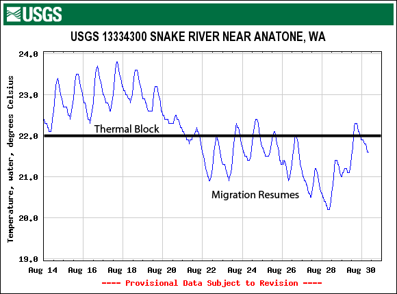
Figure 4
The temperatures on the Snake below Hell’s Canyon dam are warmer in November and December than the Salmon and Clearwater, because the water comes off the top of Hells Canyon reservoir. Temps on the Salmon may be in the mid 30s and the Snake River at Pittsburg landing is still in the 40s. Idaho Power has temperature information online for the Snake at Oxbow.
Use a hydrograph with a temperature sensor to watch for favorable water temperatures. Some key gauges with temperature sensors are the Salmon at White Bird, the Snake at Annatone, the Clearwater at Spalding, the Clearwater at Orofino and the SF Clearwater at Stites.
Summary
Steelhead are influenced by river flows and temperatures. Use hydrographs to find optimum fishing conditions and avoid poor fishing conditions. Monitor your favorite river and watch for freshettes, dropping flows, or improving water temperatures and then go fishing! Keep notes on what river flows were when a river fishes well and check the gauge before the next trip and cross reference the flow to your notes. Your success will increase.
River Flow Web Sites
Here are links to some different streamflow pages on the web.
USGS Real Time Streamflows
http://waterdata.usgs.gov/nwis/rt
Idaho Streamflows
http://waterdata.usgs.gov/id/nwis/current/?type=flow
Idaho - Clearwater at Spalding
http://waterdata.usgs.gov/id/nwis/uv/?site_no=13342500&PARAmeter_cd=00065,00060
Idaho - Clearwater at Orofino
http://waterdata.usgs.gov/id/nwis/uv/?site_no=13340000&PARAmeter_cd=00065,00060
Idaho - Salmon at Whitebird
http://waterdata.usgs.gov/id/nwis/uv?cb_00010=on&cb_00060=on&cb_00065=on&format=gif_default&period=21&site_no=13317000
Idaho - Salmon at Shoup
http://waterdata.usgs.gov/id/nwis/uv/?site_no=13307000&PARAmeter_cd=00065,00060
Idaho - Upper Salmon at Yankee Fork
http://waterdata.usgs.gov/id/nwis/uv/?site_no=13296500&PARAmeter_cd=00065,00060
Idaho - Snake at Anatone
http://waterdata.usgs.gov/id/nwis/uv?cb_00060=on&cb_00065=on&cb_00010=on&format=gif_default&period=21&site_no=13334300
Oregon River Flows
http://waterdata.usgs.gov/or/nwis/current/?type=flow
Oregon - Grande Ronde
http://waterdata.usgs.gov/or/nwis/uv/?site_no=13333000&PARAmeter_cd=00065,00060
Idaho Power Hells Canyon Flows and Forecast
http://www.idahopower.com/riversrec/waterlevels/hellsrivflw.cfm
http://waterdata.usgs.gov/id/nwis/uv/?site_no=13290450&PARAmeter_cd=00065,00060
Idaho Power Oxbow Temps
http://www.idahopower.com/riversrec/waterlevels/oxbow.asp
River Forecasts
http://www.nwrfc.noaa.gov/
Comments
rick fullerton
I have tried in vane to get the info on the cfs of the northfork clearwater below Dworshak Dam. If you know a site, I would appreciate it. Thank You
Brian
I'm just wondering if tomorrow (30th) is a good day to go catfishing. I researched that the moon is full 3.3 days before last quarter. I.m very new to the site.
Thank You
Brian